CI is planning to improve performance of rapid response remote sensing systems through use of community-contributed content and validation.
CI's real-time forest monitoring systems generate daily alerts, maps and reports used by national and sub-national government agencies, NGO's, scientists, communities, and the media to understand, respond to, and report on threats to forest resources. Currently, the systems support more than 730 subscribers from Madagascar, Indonesia, Bolivia and Peru.
Despite the timeliness of the alerts, the free- or low-cost satellite data used by these systems (MODIS, Landsat, ASTER and AVNIR) may fail to detect certain types of illegal activity such as sub-canopy fire, selective logging, or hunting. Limited satellite image resolution, the effects of cloud cover, and discontinuous observations from orbiting remote sensing platforms means that only a fraction of illegal activity is actually detected while it is underway. Enforcement of illegal activity would be significantly enhanced with the addition of field-based remote sensing observations focusing on high risk areas, collected and shared by field-based practitioners and enforcement personnel. Field-based information would not only fill gaps in the satellite data record, enabling a more comprehensive response, but improve the accuracy assessment of satellite observations.
In an effort to create a formal mechanism for users and partners to contribute to the forest monitoring systems and provide feedback on the data accuracy, we plan to expand the network of existing subscribers — often park patrols and their NGO or community counterparts — and enact modifications to the existing communications infrastructure that accommodate data upload from mobile phones and field sensors. We will add a moderated blog to the existing website where users may anonymously contribute information on suspected illegal activity (backed by published reports) and other relevant information. We will hope to test field sensor technologies, such as a system developed by Wildland Security, that utilizes wireless field sensors (magnetometers and cameras) placed along heavily trafficked trails to communicate real-time alerts via Internet gateways to satellite communications networks (e.g., Thuraya) and a central alert processing system.
Conservation International (CI)
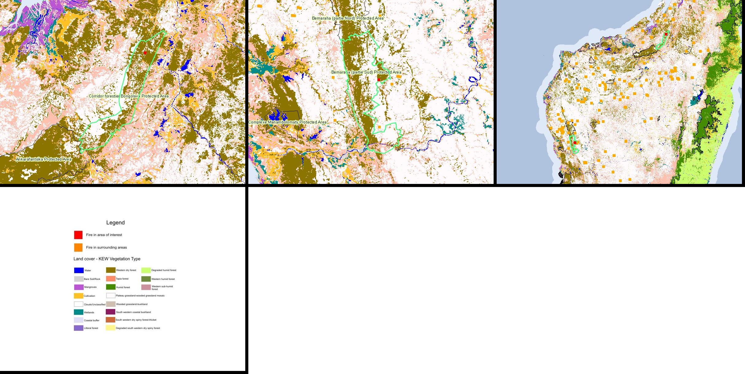
Conservation International's real-time forest monitoring systems disseminate daily email alerts on fires detected by NASA's Terra and Aqua satellites for Bolivia, Peru, Indonesia and Madagascar; daily on-line maps of fire risk for the SW Amazon; and periodic email illegal logging and encroachment alerts for parks in Indonesia. Version 2.0 of the Fire Alert System (FAS) website operates in English, Spanish, French and Indonesian. It allows users to tailor their alert subscriptions and email attachments (custom images, text files, GIS shape files and KML files) to focus on country-specific "areas of interest", including protected areas, key biodiversity areas, indigenous areas, vegetation and forest cover types, administrative boundaries, and forest concessions. Users also may download automated reports and maps documenting historical fire and suspected illegal forestry activity. Future enhancements will include incorporation of peat lands and climate change mitigation sites, and SMS text messaging.
The Fire Risk System is a satellite-driven model using empirical equations from the U.S. Forest Service's National Fire Danger Rating System. It generates daily index maps of fire risk based on the previous day's litter moisture content and the current day's air atmospheric conditions. Maps downloadable from the website include fire risk, fire risk confidence, daily rainfall sum, days since last rainfall, and Keetch-Byram drought index.
The Fire Alert System was developed in collaboration with the University of Maryland's Fire Information for Resource Management System (FIRMS), NASA's MODIS Rapid Response System, International Resources Group (IRG), Madagascar's Ministry of Environment, Forests and Tourism (MEFT) and the US Agency for International Development (USAID). The Fire Risk Monitoring System was developed in conjunction with NASA and Mexico's National Biodiversity Institute (CONABIO). Funding for these systems was provided by NASA, USAID, the American Forests and Paper Association, the U.S. Department of State, Ruth and Ben Hammett, and the Gordon and Betty Moore Foundation.
To be posted when available.
| Project Lead | John Musinsky (j.musinsky@conservation.org) |
| Fire Alert System Website | http://firealerts.conservation.org |
| Fire Risk System Website | http://firerisk.conservation.org |
Fire Alert System notification imagery showing fires in two areas of Madagascar, obtained from the Terra satellite.