Wiki-based community tools for analyzing remote sensing imagery.
A project under the leadership of the International Institute for Applied Systems Analysis (IIASA), developed with funding provide by European Community's Sixth and Seventh Framework Programme (FP6/FP7) under grant agreement No. 037063 (GOCE), Global Earth Observation – Benefit Estimation: Now, Next and Emerging (GEOBENE) and EuroGEOSS.
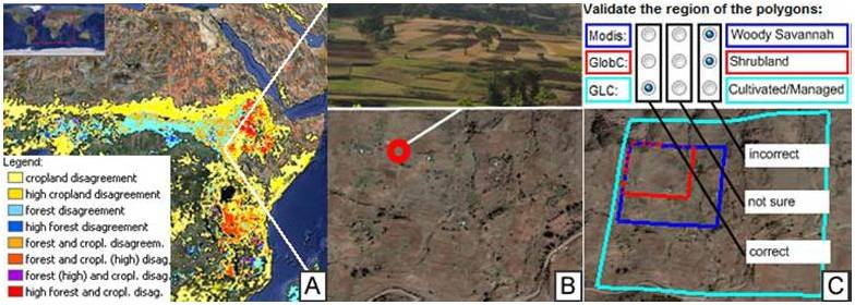
Global land cover is one of the essential terrestrial baseline datasets available for ecosystem modeling, however uncertainty remains an issue. Tools such as Google Earth offer enormous potential for land cover validation. With an ever increasing amount of very fine spatial resolution images (up to 50 cm × 50 cm) available on Google Earth, it is becoming possible for every Internet user (including non remote sensing experts) to distinguish land cover features with a high degree of reliability. Such an approach is inexpensive and allows Internet users from any region of the world to get involved in this global validation exercise. The Geo-Wiki Project is a global network of volunteers who wish to help improve the quality of global land cover maps. Since large differences occur between existing global land cover maps, current ecosystem and land-use science lacks crucial accurate data (e.g., to determine the potential of additional agricultural land available to grow crops in Africa), volunteers are asked to review hotspot maps of global land cover disagreement and determine, based on what they actually see in Google Earth and their local knowledge, if the land cover maps are correct or incorrect. Their input is recorded in a database, along with uploaded photos, to be used in the future for the creation of a new and improved hybrid global land cover map.
To be posted when available.
| Project Lead | Steffen Fritz (fritz@iiasa.ac.at) |
| Project Website | http://geo-wiki.org |
| IGARSS land cover validation competition | http://igarss.geo-wiki.org/ |
| YouTube Video | http://www.youtube.com/watch?v=thHYRkIWu-g |
The geo-wiki.org volunteers have the ability to view both cropland and forest disagreement maps derived from three recent global land cover datasets GLC-2000, MODIS and GlobCover, (B) select and visualize with the help of Google Earth available high resolution images as well as upload or view geo-tagged field pictures (e.g., from Panoramio.com, Confluence.org), and (C) determine which land cover type is found on the ground and decide which dataset is correct, incorrect or if the validater is not sure. Results are recorded in a spatial database.